Welcome to Geo-SAM’s documentation#
Note
🎉 GeoSAM is now on the QGIS Official Plugin Repository! Install and update Geo-SAM directly from the QGIS Plugin Manager – Plugins > Manage and Install Plugins, search for “Geo SAM”, and click Install. No manual download needed.
By Zhuoyi Zhao (Joey) and Chengyan Fan (Fancy) from Cryosphere Lab, ESSC, CUHK.
Introduction#
Geo-SAM is a QGIS plugin that helps you segment, delineate, and label
landforms in large geospatial raster images. It is built on the
Segment Anything Model (SAM) and uses the
strategies of encoding image features in advance and stripping the heavy image
encoder from inference. The interactive segmentation runs at millisecond
speeds on a laptop CPU, making it a convenient and efficient tool for remote
sensing image analysis.
Since v2.0, Geo-SAM provides two segmentation workflows:
Live Encoding mode – Select a raster layer and a SAM model, then start segmenting. The plugin encodes features on the fly using QGIS background tasks and caches them for fast re-queries. This is the recommended workflow for most users.
Pre-encoded mode – Use the Image Encoder to generate reusable feature files from a raster, then load them in the Segmentation tool. Ideal when segmenting the same image repeatedly or when encoding on a remote server.
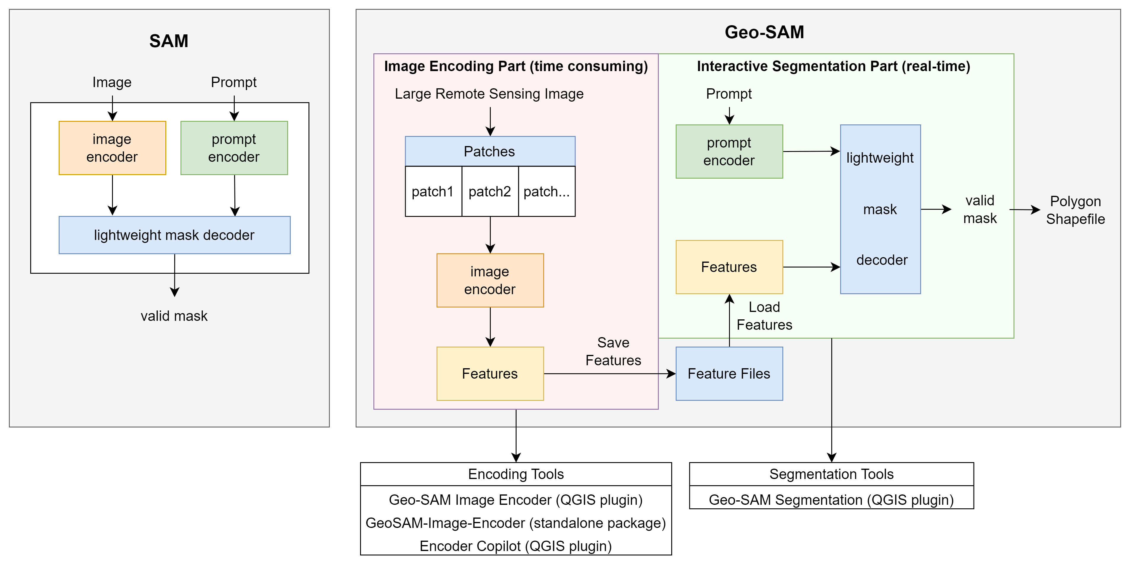
Comparison of the workflow between Geo-SAM and the original SAM. The
original SAM encodes prompts and image simultaneously, while Geo-SAM
encodes image features in advance and queries prompts at millisecond
speeds by loading those saved features.#
Reasons for choosing Geo-SAM#
QGIS-based – cross-platform GUI with no programming skills required.
Fast feedback – segmentation appears
instantly after giving prompts, and can even follow the mouse cursor inPreview modefor a smooth, interactive labelling experience.Dual workflow – segment directly from an image layer or from pre-encoded feature files.
Multi-band support – adapted to handle one or two-band images (grayscale, NDVI, NDWI, SAR) in addition to standard three-band RGB.
SAM model family support – SAM, SAM 2, SAM 2.1, and SAM 3.
Multi-language UI – the interface is available in 中文, 日本語, 한국어, Français, Русский, العربية, Deutsch, Español, and Português, following the QGIS locale setting automatically.
Note
SAM is designed to segment one object at a time with a series of prompts. Save the current results before moving to the next object.
The Geo-SAM plugin is in active development. For questions or suggestions, please open an issue on GitHub.